On April 26, NOAA announced that Raytheon Intelligence & Space (RI&S) would be the development partner that would unite the community in developing the most user-friendly and user-accessible Earth modeling system in the world. This marks the end of a two-year planning process to establish the Earth Prediction Innovation Center (EPIC), and an exciting starting point for community members from academia, industry and government to work together to enable the most accurate and reliable operational numerical forecast model in the world.
Issue 27 | Autumn 2021
Lead Story
An EPIC Journey Toward Open Innovation and Development to Advance Operational Numerical Weather Prediction Systems
Contributed by Maoyi Huang, EPIC Program Manager, Weather Program Office, NOAA
EPIC and DTC will join forces to allow a much faster rate of innovation to research and to operations.
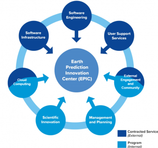
The vision of EPIC can be traced back to 16 years ago when our beloved colleague and leader, Dr. William Lapenta, was the acting director of the Environmental Modeling Center, as part of his effort to reshape NOAA’s culture and stand up a path for the United States to reclaim and maintain international leadership in the development of operational numerical weather prediction systems. This vision has been embraced warmly by the weather enterprise, as well as NOAA leadership and U.S. lawmakers. In 2018, the National Integrated Drought Information System Reauthorization Act instructed NOAA to establish EPIC to accelerate community-developed scientific and technological enhancements into the operational applications for numerical weather prediction (NWP). NOAA’s Weather Program Office has started a journey to formally implement EPIC as a program since then. An overview of EPIC’s seven investment areas is shown in Figure 1.

Figure 1. EPIC’s Seven Investment Areas. Light blue areas stand for functions of the program management team at NOAA WPO. Dark blue areas represent services provided in the contract led by RI&S.
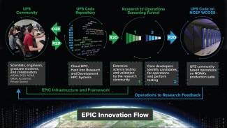
The NOAA-RI&S partnership will take us to a next level toward seamless integration of the numerical modeling community across boundaries, to fulfill EPIC’s mission as catalyst for community research and modeling system advances that continually inform and accelerate advances in our nation’s operational forecast modeling systems, as illustrated in Figure 2. EPIC is working on setting up a public-facing virtual community model development platform populated with the Unified Forecast System codes, supporting datasets and test cases, providing community support in forms of online tutorials, community workshops, and a dedicated service desk, and implementing Continuous Integration/Continuous Delivery (CI/CD) pipelines on cloud and on-premises HPCs to enable Agile development, security, and operations (DevSecOps) processes that can greatly accelerate the infusion and testing of new ideas and innovations for model improvements and enhancements.
DTC’s experience and expertise in code management and user and developer support for the UFS weather model code base and applications are indispensable assets to the community. EPIC looks forward to working with DTC closely to offload these responsibilities, so that DTC can focus its resources and expertise on testing and evaluation to accelerate hierarchical testing of model physics and final transition to operations. What’s more important, EPIC and DTC will join forces to allow a much faster rate of innovation to research and to operations. An EPIC journey will continue to advance operational numerical weather prediction systems in open innovation and development for years to come.

Figure 2. EPIC as catalyst for community research and modeling system advances.
Director's Corner
Participating in Research-to-Operations process through the DTC
Michael Toy
Contributed by Michael Toy


The DTC plays a vital role in the development of the Unified Forecast System (UFS), particularly in the areas of physics parameterization development, and testing and evaluation (T&E). In these ways, the DTC is facilitating research to operations (R2O) efforts from a broad scientific community. Recently, I became a member of this community as a model-physics parameterization developer, coming from a background in experimental dynamical core development, the intricacies of which had become very familiar to me.
Being tasked to add a new physical parameterization module, which is code that describes the grid-scale evolution of forecast variables due to sub-grid scale (unresolved) physical processes to a highly complex model like the UFS Weather Model, was quite daunting. The Common Community Physics Package (CCPP), developed by the DTC, made the development process more manageable by providing a modular structure to the physics parameterization where one codes more or less as one wishes, and the code gets connected to the dynamical core of the UFS Weather Model (i.e., FV3 - Finite-Volume Cubed-Sphere), or that of any other model, with a skillfully designed software interface. The CCPP makes it easy to test different combinations of parameterizations, and to combine aspects of separate schemes to find the optimal configurations for future versions of the operational UFS.
Michael Toy, NOAA
Serving as the DTC Science Advisory Board (SAB) chair at the annual SAB meeting in September was an honor. The SAB consists of scientists in the UFS community from government laboratories, the Department of Defense, academia and the private sector. It was good to hear first-hand perspectives from stakeholders, who are not all model developers, about guidance on DTC's strategic direction and objectives. There is optimism that the transfer of code management and support to the Earth Prediction Innovation Center (EPIC) will free DTC's resources in expertise to more science related activities such as further T&E development, facilitating physics parameterization innovations, and increased training and outreach to the broader UFS community. There is also interest in seeing the METplus verification system become more widely used, and this will certainly be facilitated through the recent addition of new tutorials on the DTC website and the upcoming training workshop, as well as acceptance of METplus into NCEP operations. From the discussions the SAB had during the September 2021 annual meeting, it is evident that the DTC is instrumental in supporting the success the UFS has had so far, and will have in the future.
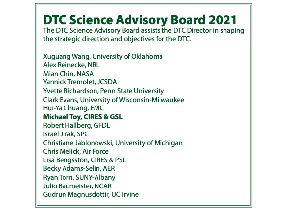
DTC Science Advisory Board 2021
Who's Who
Ka Yee Wong
Ka Yee Wong was born in Hong Kong, the British colony once known as “The Pearl of the East,'' before the 1997 handover to China from the British government. She grew up in a large family, the fifth of six children (four sisters and a brother). Ka Yee was very active in school sports, shining as the only girl who played competitive ping pong and basketball with the boys. As a child, Ka Yee loved exploring the outside world, especially gazing up at the sky. In her words she “loved watching the clouds moving from one part of the sky to another, rain falling from the sky, lightning during a storm, and her favorite was looking out of the window when a typhoon made landfall.”
Science was her favorite subject in elementary school. This was further fueled by her trips to the public library to read science books even though she couldn’t yet understand English at that age. But just the pictures in these books inspired her so much that she wanted to learn more, and this inspiration motivated many of her future educational choices.
She grew up in a typhoon hotspot influencing her desire to be a typhoon forecaster who would serve the safety of her fellow citizens by predicting the weather. She attended UCLA where she received her undergraduate degree with a double major of atmospheric/oceanic sciences and mathematics, then earned a masters degree in atmospheric sciences. In graduate school, she was a teaching assistant for the meteorology and air pollution classes, where she discovered that she had a talent and love for teaching. Her master thesis work explored how microphysics schemes and initial environmental relative humidity impact the hurricane track and intensity performance in WRF idealized simulations without the presence of land, thus WRF simulations solely over water.
Currently, she is a CSU CIRA Associate Scientist who has been actively involved with several diverse projects since finishing graduate school in 2009. Many of these projects made a lasting impression on her. She gained a great deal of knowledge and inspiration from projects such as the Nonhydrostatic Icosahedral Model (NIM), WRF-CHEM, Unified Post Processor (UPP), and High-Resolution Rapid Refresh Smoke (HRRR-smoke). From a series of NWP model projects such as the MM5 (undergraduate), WRF (graduate+early career), and FV3 (current model), she saw how the models evolved and became more sophisticated. Ka Yee is very proud to be a member of the meteorological community, to contribute her knowledge, and further dedicate her career to this field.
Ka Yee explained to her oldest son, now 8, that her job working on weather models requires a lot of software development or “coding.” She made the analogy of how it is similar to playing video games. Each player tries to advance to each higher level of the game until the end, so her job is to write/debug code to advance toward her goal and move on to the next level as well. She loves her job and enjoys every day of work.
She married her husband Athanasios, who is of Greek origin, on a numerically auspicious day, 2011-11-11. In so doing, they also married the two ancient cultures and traditions of their families. She is now a mother of three children, with two young boys and a 6-month old daughter. Her family is very active; enjoying basketball/ snowboarding/ hiking/ video gaming/ and travel. Ka Yee is looking forward to the future and how it will unfold both for advancements in forecast models as well as her children as they grow up and navigate their own lives. Her personal mantra is: In our journey of life, we will certainly encounter many storms. Even so, we will endure as we pass surely and steadily through every storm of life. After each storm comes the rainbow!
Ka Yee Wong with son Michael, daughter Antigone, and son Raphael
Bridges to Operations
Highlights of the 2021 NOAA Hazardous Weather Testbed Spring Forecasting Experiment
Contributed by Adam Clark, NSSL
Although the COVID pandemic has precluded in-person experiments for nearly two years in NOAA’s Hazardous Weather Testbed, virtual Spring Forecasting Experiments (SFEs) have proven to be an effective way to maintain momentum in key research-to-operations activities. SFEs are annual, 5-week severe-weather forecasting experiments led by NOAA’s Storm Prediction Center and National Severe Storms Laboratory in Norman, Oklahoma. After pivoting to a virtual format for SFE 2020, which limited the scope of activities, the 2021 SFE featured a full slate of virtual experimental forecasting and model evaluations that were made possible through well-vetted virtual meeting tools, web-based drawing tools coupled with experimental model-guidance visualizations, and interactive model-comparison webpages. Without physical space constraints, the 2021 SFE was able to accommodate a record number of participants: 130 forecasters, researchers, and students from around the world.
The 2021 SFE was held 3 May – 4 June 2021. The primary goals of the experiment included testing new severe-weather prediction tools, studying how end-users apply severe weather guidance, and facilitating experiments for optimizing convection-allowing model (CAM) ensemble design to inform Unified Forecast System (UFS) development. A comprehensive report on 2021 SFE preliminary findings and results was recently completed and can be found here, Preliminary Findings and Results. A few highlights from the experiment are described below.
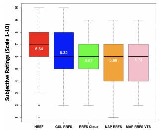
Afternoon forecasting activities emphasized the use of NSSL’s Warn-on-Forecast System (WoFS) for providing short-term severe-weather guidance. WoFS is an on-demand, CAM ensemble system that features rapidly updating ensemble data assimilation that incorporates radar and satellite data every 15 minutes. WoFS is designed to increase warning lead times for hazardous weather with tentative plans to transition to operations for the NWS in the 2025-30 timeframe. In one activity, two groups issued the same set of short-term severe-weather outlooks, but one group used WoFS and the other didn’t. Each group had two expert forecasters whose outlooks were subjectively rated on a scale of 1-10. Further, each group had several non-expert forecasters whose outlooks were combined to form consensus outlooks, which were also subjectively rated. While there was little difference between the consensus WoFS and No-WoFS outlooks, the outlooks produced by expert forecasters using WoFS were rated significantly higher (Welch’s t test using α =0.05) than the experts who did not use WoFS (Figure 1).
Figure 1. Average subjective ratings of WoFS and No-WoFS forecasts from the 2021 SFE.
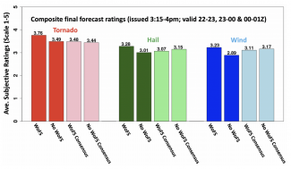
Model evaluation activities emphasized the 64-member Community Leveraged Unified Ensemble (CLUE), a framework for SFE collaborators to contribute CAMs for controlled experiments. CLUE experiments examined data assimilation methods, strategies for single-model CAM ensemble design, and impact of regional domain size on Day 2 model performance. In one CLUE evaluation, configuration strategies for a Rapid Refresh Forecast System (RRFS) were examined. The RRFS is a rapidly-updating CAM ensemble that will use the UFS Short Range Weather Application, and will subsume several regional models to simplify NOAA’s modeling suite. Subjective evaluations indicated that a prototype RRFS from NOAA Global Systems Laboratory, which used stochastic physics and initial conditions from operational HRRRDAS (High Resolution Rapid Refresh data assimilation system), performed quite well (Figure 2). In fact, this configuration almost performed as well as HREFv3 – NOAA’s current operational CAM ensemble, which continues to stand as a formidable baseline for experimental CAM ensembles. NSSL maintains an archive of past and present CLUE datasets, which can be made available upon request (Contacts are Adam Clark [adam.clark@noaa.gov] or Kent Knopfmeier [kent.knopfmeier@noaa.gov]).

Figure 2. Distributions of subjective ratings (1-10) by SFE participants of severe-weather fields over a mesoscale area of interest for the forecast hours 13-36 for HREF, GSL RRFS, RRFS Cloud, MAP RRFS, and MAP RRFS VTS. The RRFS cloud configuration was contributed by EMC and GSL and used stochastic physics, mixed physics, and cold start from GFS and GEFS initial and lateral boundary conditions. The MAP RRFS and MAP RRFS VTS were contributed by the Multi-scale data Assimilation and Predictability (MAP) group at the University of Oklahoma, and used GSI hybrid EnVar data assimilation with initial and lateral boundary conditions from GFS and GEFS. The runs labeled “VTS” also used a technique known as Valid Time Shifting to artificially increase the number of background ensemble members used for data assimilation.
Visitors
Cloud Overlap Enhancements Adopted for HWRF Operations
Visitors: Michael Iacono and John Henderson
Contributed by Michael Iacono and John Henderson

During their recent project for the DTC Visitor Program, Michael Iacono and John Henderson of Atmospheric and Environmental Research (AER) used the Hurricane Weather Research and Forecasting model (HWRF) to investigate an improved way to represent the sub-grid variability and vertical overlap of partial cloudiness within the calculation of atmospheric radiative transfer. Their exponential-random (ER) cloud overlap advancement was adopted by NOAA in the 2020 operational HWRF.
Clouds are a critical component of Earth’s climate in that they strongly affect both the incoming solar (or shortwave) energy, which fuels the climate system, and the thermal (or longwave) energy that is emitted by the surface and partially escapes to space after being transmitted, absorbed, and reemitted by the atmosphere. Understanding the way that clouds absorb, emit, and scatter radiation is essential to modeling their role in Earth’s radiative processes.
One limitation to simulating clouds and their radiative impact accurately is the challenge of representing their variability on scales smaller than the typical grid spacing of dynamical atmospheric models such as HWRF and the NOAA Unified Forecast System (UFS). Radiative transfer through sub-grid scale clouds strongly depends on whether the clouds are vertically correlated, such as in tall thunderstorm clouds, or uncorrelated such as for randomly oriented, shallow cumulus under high thin cirrus. This radiative process is also strongly dependent on properly simulating cloud fraction and cloud physical and optical properties.
Using the RRTMG radiation code in HWRF, the primary objective of this project was to establish the relative benefits of using the exponential (EXP) cloud overlap assumption, which became operational in HWRF in 2018, and the ER method. Both approaches have been shown to be more realistic relative to radar measurements within vertically deep clouds compared to the older maximum-random (MR) method. The MR approach forces the clouds to be more vertically coherent throughout adjacent partly cloudy layers, while the EXP and ER methods relax this restriction by allowing the correlation to transition exponentially from maximum to random with vertical distance through the cloudy layers with small adjustment possible via a decorrelation length parameter. ER adds a further degree of randomization between cloudy layers separated by clear sky relative to EXP. The exponential treatments have the effect of increasing total cloudiness and reducing shortwave radiation reaching the surface relative to MR overlap.

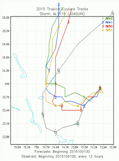
H220 forecast tracks over the first 60 hours with storm positions plotted every 12 hours for four predictions of Hurricane Joaquin initialized at 0000 UTC on 1 October 2015 for a set of four variations of ER cloud overlap. Best track observed positions of Joaquin are shown in black.
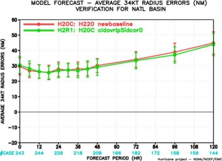
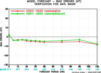
To assess this advancement in HWRF, hurricane simulations were completed with the assistance of the DTC and NOAA/EMC for multiple tropical cyclones using EXP or ER cloud fraction overlap and two methods for specifying the decorrelation length. Hurricane Joaquin, a 2015 Atlantic basin storm with an unusual track that was challenging to predict, was especially sensitive to the cloud overlap configuration as seen in the first figure, which shows the forecast track using four variations of the new cloud overlap methods. Statistics for a broader set of six Atlantic hurricanes, including the relative change in wind speed bias errors and in 34-knot wind radius errors seen in the second figure, suggest improvement using ER relative to the EXP cloud overlap method.
Our interactions with the DTC have been a rewarding opportunity not only to acquire new insights on this research topic, but also to transition critical physics enhancements to NOAA operations, and we will continue to pursue further research collaborations with the DTC and NOAA/EMC in the future.


Operational 2020 HWRF-predicted wind speed bias errors (top; in knots) and average 34-knot radius errors (bottom; in nautical miles) for two sets of predictions using EXP cloud overlap (H20C; red) and ER cloud overlap (H2R1; green) averaged over six North Atlantic tropical cyclones. Graphics provided by Bin Liu (IMSG at NOAA/EMC).

AER's Michael Iacono (left) and John Henderson (right)
(See Winter 2017 DTC Visitor article by Michael Iacono and John Henderson.)
Community Connections
Introducing the Unified Forecast System Case Studies Platform
Contributed by Xia Sun, Dominikus Heinzeller, and Ligia Bernardet

The Unified Forecast System (UFS) Case Studies platform offers resources for conducting case studies that represent the evolving forecast challenges of NOAA’s operational Global Forecast System (GFS). This platform is the outcome of a DTC project funded by the 2019 Disaster Related Appropriation Supplemental: Improving Forecasting and Assimilation (DRAS 19 IFAA), also known as NOAA’s Hurricane Supplemental. The platform’s overarching goal is to facilitate the development of model physics innovations and their transitions to operations by exercising the Hierarchical Testing Framework (HTF) coupled with the Common Community Physics Package (CCPP). This project is developing the CCPP capability to output physics tendencies that supports the overall goal. And, leveraging newly developed CCPP capabilities and the CCPP Single Column Model (SCM) to investigate forecast issues using the UFS Case Studies catalog demonstrating to the community how to utilize this platform.
Case studies are an integral component of the HTF as they serve as an entry point for model innovations to be carefully exercised before they can be considered for comprehensive tests that use larger samples. The current set of ten cases covers atmospheric phenomena such as local temperature inversions, hurricanes, winter storms, extreme temperature events, and summertime convection. These cases illustrate forecast issues identified for GFS v16, which has been operational since March 2021. The case catalog was established in collaboration with both the Model Evaluation Group (MEG) at NOAA Environmental Modeling Center (EMC) and colleagues at NOAA Global Systems Laboratory (GSL).
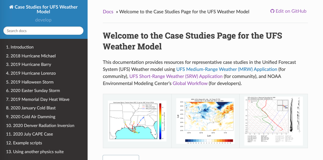
Snapshot of the landing page of the UFS Case Studies Platform
The newly established UFS Case Studies platform includes initial condition (IC) datasets housed on Amazon S3 cloud storage, model configurations, simulation results including the general synoptic patterns and particular meteorological fields that elucidate model issues, and a suite of data-visualization example scripts using Python. Cases included in the UFS Case Studies Platform have been incorporated in the physics testing procedure in the UFS Research to Operation (R2O) Project, which is a multi-year effort that convened NOAA and non-NOAA scientists to work on the operational model.
This platform is designed to serve both the research community and model developers. For researchers, the platform provides resources using the public releases of the UFS Medium-Range Weather (MRW) Application (App) and UFS Short-Range Weather (SRW) App. The SRW App and MRW App target weather predictions on timescales of two weeks and several days, and on limited-area and global domains, respectively. For developers, the platform helps ensure the advanced physics schemes implemented in the next version of the operational model outperform earlier ones. The platform provides information and verification results for the ongoing model development using codes hosted in official UFS GitHub repositories. It is possible to test alternative physics suites composed of different sets of physics parameterizations in addition to the supported suites from the UFS public releases. The platform provides information and links for interested readers with the desired guidance.

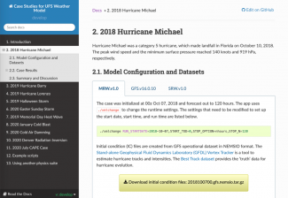
Snapshot of the case page for 2018 Hurricane Michael
In summary, the UFS Case Studies Platform bridges the gap between research and operational communities with resources that foster and advance model development. The platform will continue to evolve as work towards GFS version17 progresses. The UFS Case Studies Team encourages questions, comments, and feedback from users. These can be posted under the Discussions section of the ufs-case-studies GitHub repository.
Did you know?
METplus Tutorial Series -- November 2021 to May 2022
Contributed by Tara Jensen
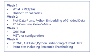

METplus will be launching a Tutorial Series on Tuesday, November 30, 2021. Participants can join METplus trainers weekly for one-hour online sessions where presentations by subject matter experts will be woven throughout the hands-on training.
Visit the METplus Training Series website to obtain more information and to register.
NOAA HPCs Hera and Jet will be used for NOAA participants that have access to these platforms. Amazon Web Services Cloud computing will be used for community participants and those at NOAA who do not have access to Hera or Jet. These three systems will have METplus installed and have data necessary for the tutorial series.
It is anticipated that the series will last 16 weeks. It will start with the basics of setting up, configuring, and running METplus then move on to core tools and eventually more advanced topics. Below is just the start.
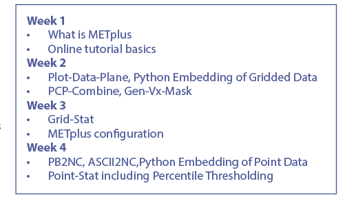
METplus Tutorial Series, weeks 1 to 4
Can't join us for the live sessions? No worries! All sessions will be made available on the METplus Training Page.
PROUD Awards
Dustin Swales, Physical Scientist, NOAA GSL |
,
Dustin Swales, a Physical Scientist at the NOAA Global Systems Laboratory, made indispensable scientific, technical, and leadership contributions to the DTC Common Community Physics Package (CCPP) project. His work was pivotal in advancing the integration of the Model for Prediction Across Scales (MPAS) dynamical core with the Unified Forecast System (UFS) Weather Model (WM) and integrating RRTMGP into CCPP.
As a key contributor to the development and testing of the CCPP Single Column Model, Dustin played a central role in creating the UFS Case Generator and its associated testing harness. This capability is now widely employed by both DTC and external scientists for hierarchical model development. Furthermore, leveraging his deep expertise in the CCPP Framework, Dustin has partnered with the NSF NCAR Climate and Global Dynamics Laboratory and the Navy Research Laboratory to engineer advanced capabilities for future implementations.
Dustin also provided vital technical leadership for the development of the MPAS-enabled UFS WM (MPAS-UFS). By guiding the technical team, establishing the capability for dycore-only execution, integrating radiation components, and developing regression tests, he has rapidly accelerated the readiness level of MPAS-UFS. Across all initiatives, Dustin is recognized as an exceptional colleague. He is consistently positive, collaborative, and driven to solve complex problems.
Through his initiative, robust cross-institutional collaborations, and proactive approach, Dustin has significantly enhanced the readiness, usability, and interoperability of the CCPP and the MPAS dynamical core. His achievements cement his position as a pillar of DTC software development and distinguish him as a highly deserving recipient of this award.

Contact
303.497.8921
dtcenter@ucar.edu
Privacy
Cookies
Web Accessibility
Terms of Use
Copyright Issues
Addresses
mailing:
PO Box 3000
Boulder, CO 80307-3000
Shipping:
3090 Center Green Dr.
Boulder, CO 80301
Follow Us
Copyright © 2026. All rights reserved.