Advection is a computationally expensive process in Numerical Weather Prediction (NWP) models. Therefore, time-sensitive operational forecast models sometimes sum up the hydrometeors, including cloud water, rainwater, ice and snow, prior to calling the advection scheme. For this configuration, the model only needs to calculate the advection of the total condensate. However, the impact of such a time-saving technique has not been systematically evaluated. With the release of HWRF 3.9a, a version of the operational HWRF microphysics scheme with separate hydrometeor advection became available to the research community, providing an excellent opportunity to study how simulated hurricane structures differ according to the advection schemes they use. As a DTC Visitor, Shaowu Bao evaluated the impact of vertical advection schemes of the hydrometeors on the simulated hurricane structure and intensity in the Hurricane Weather Research and Forecasting (HWRF) model.
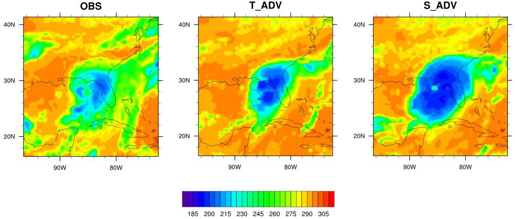
Hurricanes Matthew (2016) Hermine (2016) and Jimena (2015) were simulated using the operational HWRF 2017 with the advection of total condensate (hereinafter T_ADV) and that of separate hydrometeors (hereinafter S_ADV). Their results were then compared against the infrared (IR) brightness temperature images data from NOAA's Geostationary Operational Environmental Satellite GOES 13.
The most distinct difference between the T_ADV and S_ADV results was the simulated storm size. In Figure 1, a deep blue IR brightness temperature indicates a cold cloud top and red-brown identifies the warm surface of the Earth with no-cloud or fewer cloud conditions. T_ADV and S_ADV produced similar storm locations and shapes that both matched the observed. However, S_ADV produced cloud coverage that was noticeably larger than that produced by T_ADV.
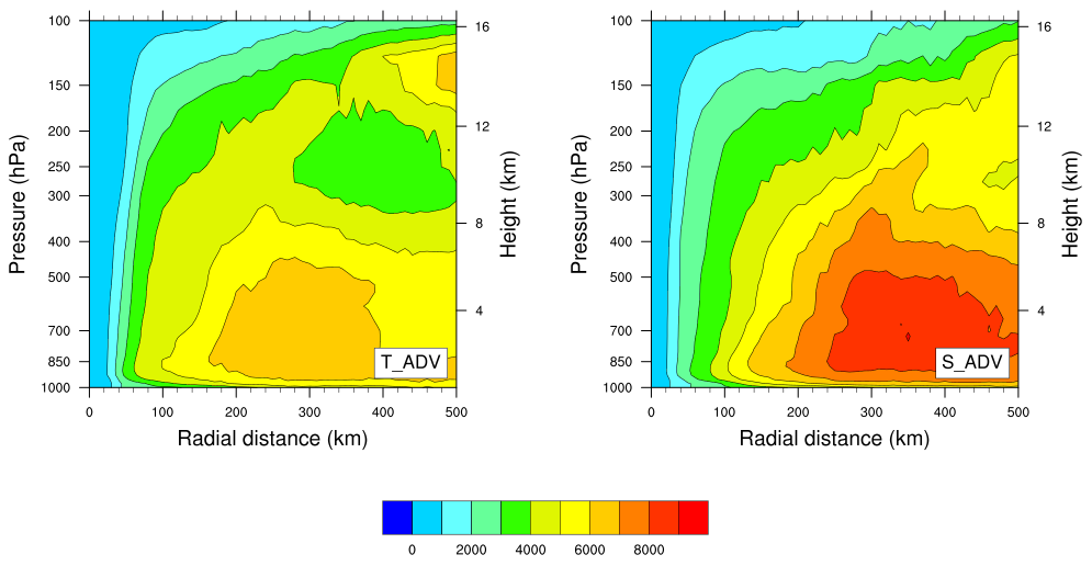
Our hypothesis suggests the total condensate advection in T_ADV overestimates the upward advection of rainwater and underestimates that of cloud water. By correcting this problem, the S_ADV scheme transports more cloud water upward than T_ADV, leading to more diabatic heating from condensation and more angular momentum to be imported into the hurricane vortex. This causes the larger size of hurricanes simulated by S_ADV than those by T_ADV. Our results of the angular momentum (Figure 2) and other analysis confirmed this hypothesis.
Although in theory the separate advection of hydrometeors in S_ADV is more realistic than the advection of total condensate in T_ADV, this evaluation showed that S_ADV simulated much larger storms than T_ADV and the observed hurricanes, and therefore degraded the HWRF performance. Future work is needed to identify the adjustments in the model that may have masked the error related to the total condensate advection, so that the separate hydrometeors advection can achieve better forecast performance.
Shaowu found that the two weeks spent at NCAR collaborating with DTC scientists was a very pleasant and productive experience. He wants to especially thank Ligia Bernardet, Evan Kalina, Mrinal Biswas, Greg Thompson and Louisa Nance, as well as Kathryn Newman. Without their help and support setting up the model, providing input data, and analyzing the results, this project was impossible to complete.