NCAR-RAL has a long track record of transitioning numerical weather prediction (NWP) model cloud microphysical schemes from research to operations.
Beginning in the 1990s, a scheme by Reisner et al (1998) was created within MM5 (Fifth-Generation Penn State/NCAR Mesoscale Model) but also transitioned to the Rapid Update Cycle (RUC) model. A few years later, the scheme was modified and updated for both MM5 and RUC by Thompson et al (2004). Then, as the Rapid Refresh (RAP) model was replacing the RUC, an entirely rewritten microphysics scheme by Thompson et al (2008) was created for operational use in the Weather Research and Forecast (WRF) and RAP models. A primary goal of each of these efforts was to improve upon the explicit prediction of supercooled liquid water and aircraft icing while also improving quantitative precipitation forecasts (QPF) and surface sensible weather elements such as precipitation type.
The established pathway for transition to operations for the Thompson et al (2008) microphysics scheme is greatly facilitated through the WRF code repository and a continual collaboration with NOAA’s Earth System Research Laboratory (ESRL) and Global Sciences Division (GSD), especially the team led by Stan Benjamin. Various improvements to the scheme are rapidly implemented into prototype operations at NOAA-GSD for further testing before they eventually transition to the National Centers for Environmental Prediction (NCEP) Environmental Modeling Center (EMC) in the fully operational RAP model at NCEP.
A more recent DTC effort has included the testing and evaluation of the Thompson et al (2008) microphysics scheme into the Hurricane WRF (HWRF) model to see if it improves tropical cyclone track and intensity forecasts. During development, the scheme’s developers had not previously worked in the area of tropical cyclone prediction, but focused instead on mid-latitude weather. The current test may reveal potential improvements to tropical storm prediction or shortcomings in the microphysics scheme that could lead to future improvements.
A second DTC effort is the incorporation of the Thompson et al (2008) microphysics scheme into NCEP’s NEMS-NMMB (NOAA Environmental Modeling System-Nonhydrostatic Multiscale Model on B-grid) model, which is also the current North American Model (NAM). As the NAM transitions to higher and higher resolution, the potential use of alternative microphysics schemes is being considered. To achieve this goal, a number of structural code changes to NEMS-NMMB model were made to accept the larger number of water species used by the Thompson et al (2008) scheme, as compared to number of species in the operational microphysics scheme. However, the extent of code changes directly within the microphysical module was very minimally different than the existing WRF code, which greatly facilitates future WRF-code transitions to NEMS-NMMB.
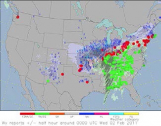
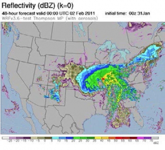
The two-panel figure above shows a 48 hour forecast of model lowest level radar reflectivity valid at 0000 UTC 02 Feb 2011 made by the WRF-ARW (top panel) model and NEMS-NMMB model (bottom panel). Particularly evident in a comparison of the two model cores are sporadic low-value dBZ forecasts seen in broad areas of the NMMB and to a much lesser degree in the WRF, suggesting a much greater presence of drizzling clouds in the NMMB. Also shown in the figure at the beginning of the article (page 1) is the WRF-predicted explicit precipitation type with blue/pink/green shades representing snow, graupel, and rain, respectively, along with an overlay of colored symbols to represent the surface weather observations of various precipitation types. The notable lack of graupel observations vis-à-vis forecasts likely reflects deficiencies of automated observations.
AMS, Thompson et al. 2008, http://journals.ametsoc.org/doi/abs/10.1175/2008MWR2387.1 and 2014, http://journals.ametsoc.org/doi/abs/10.1175/JAS-D-13-0305.1

