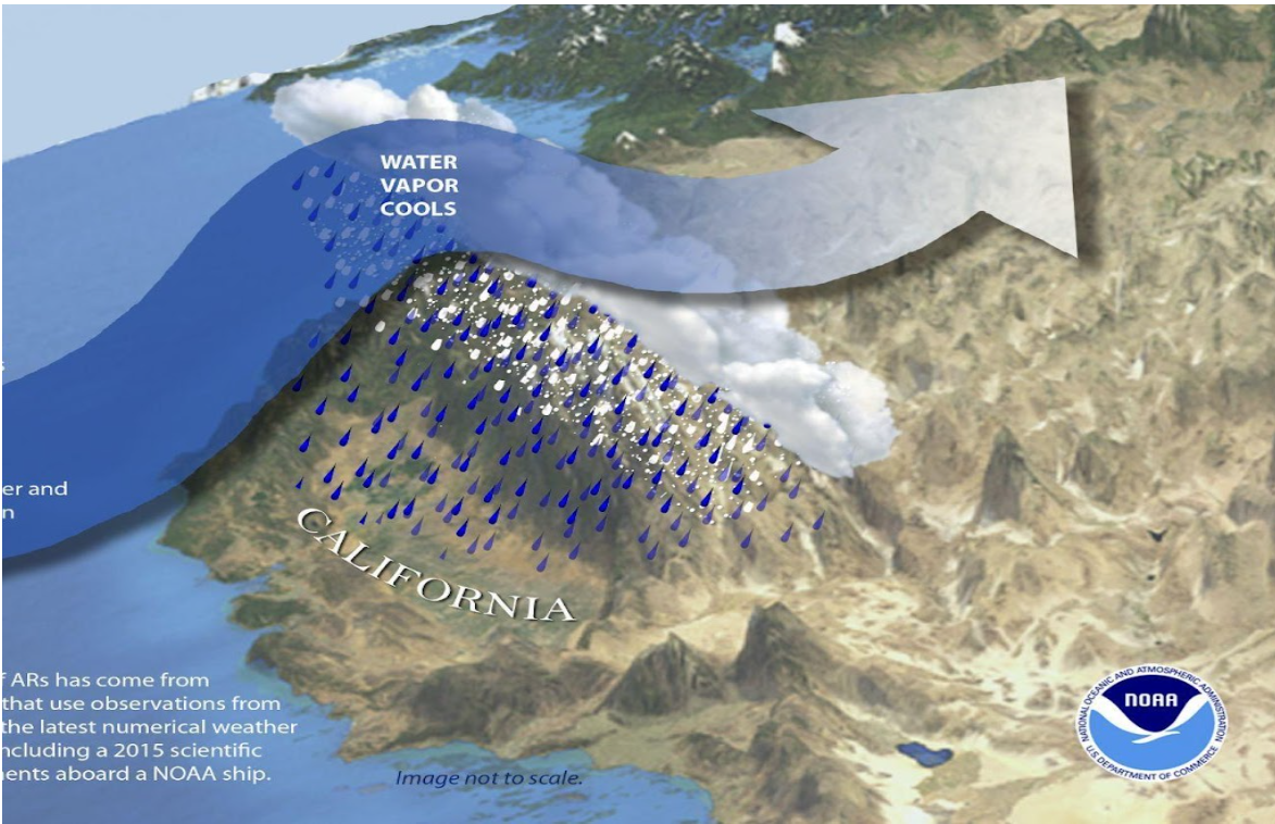
Atmospheric Rivers (ARs) are large streams of atmospheric moisture that form over the ocean and flow to the coast. Complex air-sea and land-atmosphere interactions associated with land-falling ARs cause heavy rainfall and flooding, among other harmful consequences across the western U. S. states and further inland. Across the 11 western states, damages average approximately $1B per year with cumulative impacts of ARs for the recent 2022-2023 winter estimated at $4.6B.
Emerging needs for water resource management and emergency preparedness for high-impact AR events require increased fidelity of forecast models. The Water in the West project aims to address the critical needs of emergency planners, water resource managers and other stakeholders for:
1) Reduced errors in the forecasted landfall position of ARs
2) Improved accuracy of QPF associated with land-falling ARs
3) Reduced errors in the model intensity of land-falling ARs
4) Reduced forecast errors in snow level for land-falling ARs
5) Improved snow-accumulation forecasts
Through FY23 and FY24 dedicated Water in the West appropriations, NOAA is undertaking a project focused on improving AR forecasts and reducing related flood damage. To improve AR forecasts, we need to accurately capture the detailed and interconnected physical processes occurring in the atmosphere, in the ocean, and over land. These processes include winds and moisture transport, formation of clouds, rain, snow, and precipitation over the mountainous terrain along the west coast of North America. At the same time, the timing and placement of the synoptic-scale steering flow largely influences where and when most of the moisture is distributed to the western portion of the Contiguous United States (CONUS) west coast. For this purpose, we configured the Unified Forecast System (UFS) to run 13-km global simulations with a 3-km regional nest over the eastern Pacific Ocean and the western CONUS, interacting in a two-way coupling over the nested domain. This UFS-AR nested-grid approach allows for more detailed and localized weather predictions within the area covered by the high-resolution nest, while also predicting the global synoptic-scale flow at longer forecast lead times without the implications associated with providing lateral boundary conditions for a standalone regional domain. The multiple efforts for this complex project are coordinated through a partnership among NOAA’s Physical Sciences Laboratory (PSL), Global Systems Laboratory (GSL), Environmental Modeling Center (EMC), Hydrometeorology Testbed, and the Earth Prediction Innovation Center (EPIC).
To achieve the best possible initial conditions for its model forecasts, NOAA uses a process referred to as data assimilation (DA) to generate a refined starting point to the model based on a variety of data sources, including satellite observations, weather stations, radiosondes, aircraft measurements, weather buoys, etc. Cycling refers to a process where the model is run for a short time to produce an initial forecast, data are collected to compare with the forecast and DA techniques are employed to mathematically combine the two to provide a refined starting point for the model. This routine is done on a regular basis as part of NOAA’s operational weather forecasts.
The Water in the West project aims to run a DA system with 80 ensemble members in a cycled manner to achieve its goal of accurately predicting AR events. Running 80 ensemble members with DA is both complex and computationally expensive. The workflow that will run this system is the next step in development for the project. NOAA plans to incorporate Artificial Intelligence/Machine Learning (AI/ML) first into the computationally expensive DA system, and later to experiment with AI/ML for the similarly expensive prediction model.
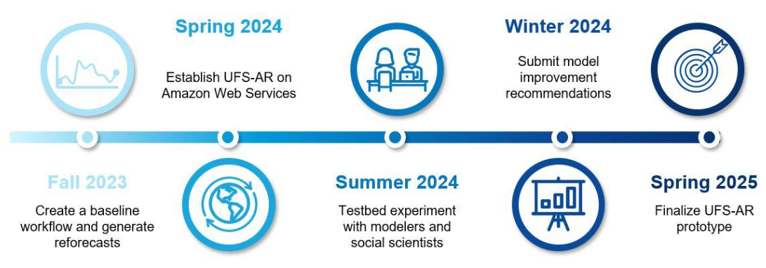
The participating organizations for the AR project are Oceanic and Atmospheric Research (OAR), National Weather Service (NWS), National Environmental Satellite, Data, and Information Service (NESDIS) of NOAA and the Center For Western Weather and Water Extremes (CW3E) of University of California, San Diego. The timeline of the implementation of the AR project is shown below. More information on this project can be found in a recent EPIC news article.