Although the COVID pandemic has precluded in-person experiments for nearly two years in NOAA’s Hazardous Weather Testbed, virtual Spring Forecasting Experiments (SFEs) have proven to be an effective way to maintain momentum in key research-to-operations activities. SFEs are annual, 5-week severe-weather forecasting experiments led by NOAA’s Storm Prediction Center and National Severe Storms Laboratory in Norman, Oklahoma. After pivoting to a virtual format for SFE 2020, which limited the scope of activities, the 2021 SFE featured a full slate of virtual experimental forecasting and model evaluations that were made possible through well-vetted virtual meeting tools, web-based drawing tools coupled with experimental model-guidance visualizations, and interactive model-comparison webpages. Without physical space constraints, the 2021 SFE was able to accommodate a record number of participants: 130 forecasters, researchers, and students from around the world.
The 2021 SFE was held 3 May – 4 June 2021. The primary goals of the experiment included testing new severe-weather prediction tools, studying how end-users apply severe weather guidance, and facilitating experiments for optimizing convection-allowing model (CAM) ensemble design to inform Unified Forecast System (UFS) development. A comprehensive report on 2021 SFE preliminary findings and results was recently completed and can be found here, Preliminary Findings and Results. A few highlights from the experiment are described below.
Afternoon forecasting activities emphasized the use of NSSL’s Warn-on-Forecast System (WoFS) for providing short-term severe-weather guidance. WoFS is an on-demand, CAM ensemble system that features rapidly updating ensemble data assimilation that incorporates radar and satellite data every 15 minutes. WoFS is designed to increase warning lead times for hazardous weather with tentative plans to transition to operations for the NWS in the 2025-30 timeframe. In one activity, two groups issued the same set of short-term severe-weather outlooks, but one group used WoFS and the other didn’t. Each group had two expert forecasters whose outlooks were subjectively rated on a scale of 1-10. Further, each group had several non-expert forecasters whose outlooks were combined to form consensus outlooks, which were also subjectively rated. While there was little difference between the consensus WoFS and No-WoFS outlooks, the outlooks produced by expert forecasters using WoFS were rated significantly higher (Welch’s t test using α =0.05) than the experts who did not use WoFS (Figure 1).
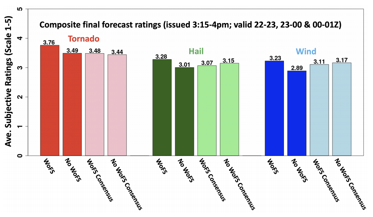
Figure 1. Average subjective ratings of WoFS and No-WoFS forecasts from the 2021 SFE.
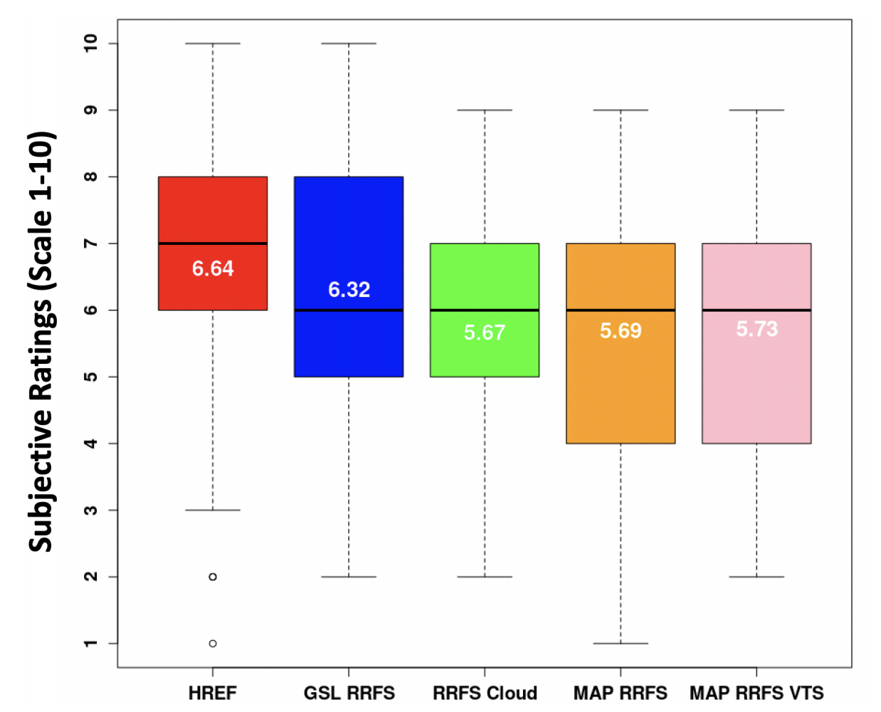
Model evaluation activities emphasized the 64-member Community Leveraged Unified Ensemble (CLUE), a framework for SFE collaborators to contribute CAMs for controlled experiments. CLUE experiments examined data assimilation methods, strategies for single-model CAM ensemble design, and impact of regional domain size on Day 2 model performance. In one CLUE evaluation, configuration strategies for a Rapid Refresh Forecast System (RRFS) were examined. The RRFS is a rapidly-updating CAM ensemble that will use the UFS Short Range Weather Application, and will subsume several regional models to simplify NOAA’s modeling suite. Subjective evaluations indicated that a prototype RRFS from NOAA Global Systems Laboratory, which used stochastic physics and initial conditions from operational HRRRDAS (High Resolution Rapid Refresh data assimilation system), performed quite well (Figure 2). In fact, this configuration almost performed as well as HREFv3 – NOAA’s current operational CAM ensemble, which continues to stand as a formidable baseline for experimental CAM ensembles. NSSL maintains an archive of past and present CLUE datasets, which can be made available upon request (Contacts are Adam Clark [adam.clark@noaa.gov] or Kent Knopfmeier [kent.knopfmeier@noaa.gov]).