The Hurricane Weather Research and Forecast system (HWRF), which is one of NOAA’s operational models used to predict the track, intensity, and structure of tropical cyclones, undergoes an upgrade cycle that is generally conducted on an annual basis. Through the code management and developer support framework provided by the DTC, innovations from the research community that have been added to branches within the HWRF code repository serve as candidates for testing as part of these upgrade cycles. Scientists at NOAA’s Environmental Modeling Center (EMC) and the Developmental Testbed Center (DTC) frequently collaborate when testing and evaluating (T&E) changes to the HWRF physics schemes or data assimilation system in hopes of improving HWRF predictions. For the 2020 HWRF upgrade cycle, the DTC focused on T&E of two potential upgrades to model physics stemming from the DTC visitor projects: 1) upgrades to the cloud-overlap scheme used in the Rapid Radiative Transfer Model for General Circulation Models (RRTMG), made available by John Henderson and Michael Iacono of Atmospheric and Environmental Research (AER) and 2) the Mellor-Yamada-Nakanishi-Niino (MYNN) Planetary Boundary Layer, based on work conducted by Dr. Robert Fovell (SUNY Albany) and a collaboration with Dr. Joseph Olson (NOAA Global Systems Laboratory).
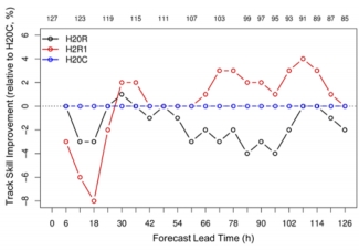
Testing these potential upgrades focused on thirteen tropical cyclones in the North Atlantic ocean from the past three years that provided a mixture of storm characteristics and previous operational model performance. Preliminary results for the cloud-overlap upgrades (four of the thirteen storms) suggested that the results would not be sufficient to warrant operational implementation. The DTC communicated this feedback to AER, and worked with them to further analyze the results. The analysis suggested that a different configuration of the cloud-overlap upgrades might perform better. After coordinating with EMC and AER, the DTC tested the revised cloud-overlap configuration. This second test demonstrated up to 4% improvement in the 3–5 day hurricane-track forecast, which was sufficient for EMC to transition the cloud-overlap changes into the 2020 operational HWRF. This process illustrates the important role of iterative testing and development when transitioning research to operations. Results from the MYNN experiment indicated the scheme was not yet ready for operational implementation. However, the results are informing additional changes to the code by the developers, which may further enhance the performance of the MYNN PBL in high-wind conditions for potential application within NOAA’s Unified Forecast System (UFS).
Since these tests were conducted, the 2020 configuration of HWRF was finalized and implemented in operations. During the summer of 2020, DTC and EMC worked together to merge the final version of the code back to the trunk of the HWRF repository. This step enables researchers to add further innovations to the latest version of the code, ensuring that any scientific results are directly applicable to the operational HWRF, and positioning the community to contribute to the next HWRF implementation in early 2021.
