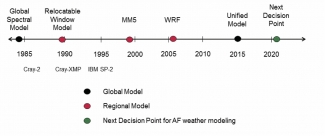
The longstanding mission of the U.S. Air Force Weather (AFW) enterprise is to maximize America’s power through the exploitation of timely, accurate, and relevant weather information, anytime, everywhere. To meet this mission, the Air Force has operated a broad range of numerical weather models to analyze and predict environmental parameters that impact military operations. The internally developed Global Spectral Model (GSM, a separate effort from the NCEP GSM) was the first operational model run by the Air Force implemented in the early 1980s. The GSM was replaced by the Relocatable Window Model (RWM) in 1990 and then in the late ‘90s Mesoscale Model 5 (MM5) went into operations. In 2006, the Weather Research and Forecasting (WRF) model became the mainstay for Air Force operations and has remained so for most of the last decade. On 1 Oct 2015, the new Global Air-Land Weather Exploitation Model (GALWEM), based on the United Kingdom Met Office’s (UKMO) Unified Model, was implemented as the Air Force’s primary weather model to meet the warfighter’s global requirements. (Figure below provides timeline of USAF weather model evolution).
Lead Story
U.S. Air Force Weather Modeling and the DTC
The Air Force is a Charter member of the DTC, as well as a number of other interagency partnerships working toward a shared goal of rapidly and cost effectively advancing U.S. weather modeling capabilities. These include the National Unified Operational Prediction Capability (NUOPC), the National Earth System Prediction Capability (ESPC), and the Joint Center for Satellite Data Assimilation (JCSDA). The science insertion, validation studies, and user product improvements developed through these partnerships have benefited AFW significantly.
The Air Force’s contributions to the DTC have focused on verification and tuning of the WRF model for a range of domains around the world; support to the standardization, documentation, and baseline management of the Gridpoint Statistical Interpolation (GSI) data assimilation system used by all of the DTC partners; and enhancing the community Model Evaluation Tools (MET) to more effectively verify clouds and other aviation parameters and to improve ensemble verification techniques.
During the next decade, the Air Force will be working with our national and international modeling partners toward a goal of consolidated capabilities to assimilate, analyze and predict parameters critical to military operations in a single model solution, independent from the model(s) used downstream of the DA system. The converged solution is expected to improve overall efficiency and reduce costs while streamlining new science insertion. We look forward to working closely with the DTC to achieve this goal.
Director's Corner
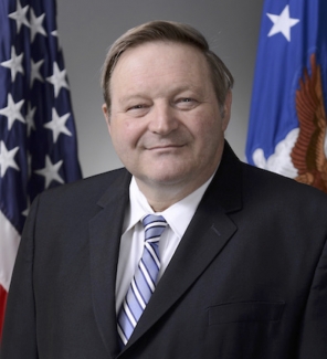
Ralph Stoffler
Ralph Stoffler, a member of the US government Senior Executive Service, is the USAF Director of Weather, and the USAF Deputy Chief of Staff for Operations. In this capacity, he is responsible for the development of weather and space environmental doctrine, policies, plans, programs, and standards in support of Army and Air Force operations. He is responsible for overseeing and advocating for Air Force weather resources and monitors the execution of the weather program. He is the functional manager for 4,300 total-force weather personnel and interfaces with Air Force major commands and the U.S. Army regarding full exploitation of Air Force weather resources and technology. He is also an AF representative on the DTC Executive Committee. See article on this page about USAF perspectives with the DTC and more.
Who's Who
Chunhua Zhou
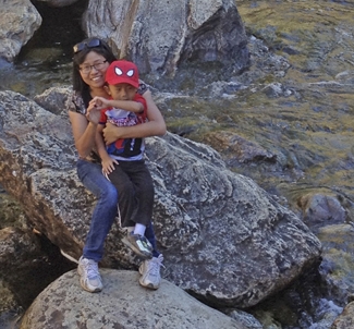
Circumstances can make it hard to connect with people, and with snowstorms and parent-teacher conferences, catching up with Chunhua Zhou took a few tries. But meeting her and learning about her work in the DTC made the effort worthwhile.
Chunhua and her younger brother grew up in central China. While he still lives there and runs a small business, Chunhua went to the University of Hawaii in 2003, receiving her Ph.D. in Meteorology in 2009. Her thesis studies involved the dynamics of the tropical intraseasonal oscillation and its interaction with the synoptic variability. Before joining the DTC, she worked as a postdoc producing daily numerical weather predictions for Hawaii using the WRF model.
Chunhua has kept quite busy since moving the DTC, working in the Data Assimilation team under Hui Shao on GSI testing and evaluation (TNE) and also community supports. Besides GSI, she has also worked on other data assimilation systems such as WRFDA. As GSI evolved from 3DVAR, to 3D ensemble-variational GSI hybrid, to the 4D ensemble-variational hybrid method, Chunhua’s efforts also shifted from GSI 3DVAR for regional application, to 3D GSI hybrid for hurricane forecasts, to the testing and evaluation of the current new capability of 4D GSI hybrid. She is also working with Josh Hacker on cloudy radiance data assimilation studies.
Chunhua enjoys living in Colorado with her husband Shenghong – a civil engineer working in Denver – and her 9-year-old daughter Sonya and 5-year-old son Jason. Asked about possibly returning to China some day, Chunhua says only for visits, as she would like to stay where she is and keep doing the work she’s doing for some time to come. So you might see her out hiking the trails in the area with her family, if there are no snowstorms or school activities, at least.
Bridges to Operations
HWRF Training at Home and Abroad
The DTC hurricane team has provided training opportunities to learn the Hurricane Weather Research and Forecasting (HWRF) system to both general users and active developers over the past several months.
The community HWRF modeling system (version 3.7a released in August 2015) is compatible with the NCEP 2015 operational implementation, which includes high-resolution deterministic tropical cyclone numerical guidance for all global oceanic basins. Due to the demonstrated skill and advanced capabilities of the HWRF model, there is a great deal of international interest for research and operational use. In order to meet these demands and foster collaborations, an HWRF tutorial was held at the Nanjing University of Information Science and Technology (NUIST) in Nanjing, China. DTC hurricane team members Ligia Bernardet and Christina Holt participated along with members of the Environmental Modeling Center (EMC) HWRF team. The tutorial, held 1-2 December 2015, attracted 84 participants and received positive feedback.
Following the China tutorial, the DTC co-hosted an HWRF tutorial with the EMC HWRF team in College Park, MD at the NOAA Center for Weather and Climate Predication. This tutorial spanned three days from 25-27 January 2016. Tutorial attendees heard over 12 hours of lectures covering all aspects of the HWRF system, as well as enrichment lectures on the HWRF multi-storm modeling system, the HWRF ensemble predication system, HYCOM ocean coupling, and forecast verification. Invited speakers participated from various institutions, including NCEP/EMC, University of Rhode Island (URI), AOML/HRD and DTC. In addition to lectures, students received 6 hours of hands-on practical sessions. The event was well received from participants, many who unexpectedly attended the tutorial remotely due to the 25+ inches of snow that fell over the DC area the weekend prior!
Presentations and materials for the College Park, MD and Nanjing, China tutorials are posted at: http://www.dtcenter.org/HurrWRF/users/tutorial/index.php.
In addition to the tutorials aimed at general users working with the publicly released code, the DTC also responded to developer requests for specialized training. To meet the needs of active developers working with the HWRF repository code, the DTC hosted two separate HWRF specific Python trainings; one in conjunction with the HFIP annual review meeting in Miami, FL, and a second joined to the HWRF tutorial in College Park, MD. Training materials and resources from the developer trainings are available at: http://www.dtcenter.org/HurrWRF/developers/docs/documents.php
Visitors
DTC Visitor Project
This winter of 2015-2016, the DTC had the pleasure of hosting visiting scientist Dr. Liantang Deng of the Numerical Weather Prediction Center, China Meteorological Administration (CMA). His visit stemmed from the combined Weather Research and Forecasting (WRF) and Global/Regional Assimilation and PrEdiction System (GRAPES) modeling workshop in 2014, when Dr. Bill Kuo, Director of the DTC, helped facilitate interactions between the DTC and CMA. During his 2-month stay, he evaluated the GRAPES model by utilizing baseline data sets within the Mesoscale Model Evaluation Testbed (MMET), a framework established by the DTC to assist the research community in efficiently demonstrating the merits of new developments.
Dr. Deng’s testing focused on the historic derecho case of 29 June 2012, which impacted many states in the Mid-western and Mid-Atlantic regions. The GRAPES model domain and forecast period were set up similarly to the MMET baseline 12-km parent domain, which covers the full CONUS region, and is integrated out to 84 hours; the initial and boundary conditions were derived from the GFS at 12 UTC on 28 June 2012. For Dr. Deng’s visit, he focused on the Advanced Research WRF (ARW) baseline, which was initialized with NAM and run with the operational Rapid Refresh (RAP) physics suite.
Post-processing of the GRAPES model output was conducted using the NCEP Unified Post-Processing (UPP) software. Even though UPP does not currently support the GRAPES model, Dr. Deng worked diligently to add and modify routines necessary for proper I/O, including addressing the vertical and horizontal grid-staggering, as well as addressing routines for select post-processed fields. These modifications are a welcome addition to UPP and can potentially be released as a community contribution in a future release. After the post-processing step, the DTC’s Model Evaluation Tools (MET) were used for the verification process and included statistical results for surface and upper-air point observations, as well as gridded precipitation observations.
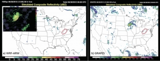
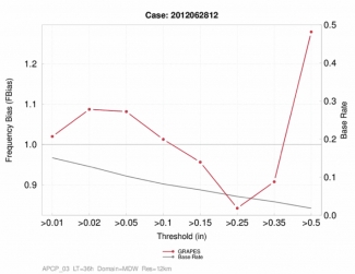
Although the GRAPES model was able to resolve a storm over the Midwest, the timing was behind and the location was too far north (Figure b). The strong leading edge observed in the storm did not form in the model, and it weakened as is moved eastward. This, compared to the ARW baseline failed to capture the event (Figure a), illustrating the impact of the different physics suites and different initial and lateral boundary conditions have on the model forecasts. The ARW initiated a storm, but instead of strengthening as it moved eastward across the Midwest, it actually dissipated. GRAPES formed a storm but was not accurate in timing, location, or forming the strong leading edge. A look at the 3-hour accumulated precipitation frequency bias at the 36 hour lead time over the Midwest (Figure below) shows a small high bias at the lowest thresholds, transitioning to a small low bias at higher thresholds, with exception of the highest threshold. This plot shows that even though the timing and location of the storm were off, GRAPES did a decent job of forecasting the accumulated precip amounts (with a little over prediction of the low thresholds and underprediction of higher thresholds).
Dr. Deng was very grateful to collaborate with the DTC and was surprised at how much he was able to accomplish in his short visit. We here at the DTC enjoyed working with him and would welcome him back for future visits to continue his work.
Community Connections
Sea Ice Modeling Workshop
A sea ice modeling workshop was convened on 3-4 February 2016 in Boulder, CO for the purpose of informing NOAA on the inclusion and selection of a community-contributed sea ice model into the future Next-Generation Global Prediction System (NGGPS). Another workshop goal was to identify potential research and development opportunities and gaps.
The workshop was hosted at the National Center for Atmospheric Research (NCAR) by the DTC’s Global Model Test Bed, and counted as sponsors the National Weather Service, the NOAA Office of Atmospheric Research Climate Program Office, and the Office of Naval Research. Sixty-five scientists attended the workshop, representing a broad spectrum of research and operational organizations, such as universities, NOAA, Navy, Department of Energy (DoE), the US National Ice Center, National Snow and Ice Data Center, NCAR, NASA, and DTC. International participation included representatives from the UK Meteorological Office, U. Reading, U. Toronto, and Environment Canada.
NOAA’s NGGPS will be a single fully coupled Earth modeling system with application to forecasts from days to seasons, spanning spatial scales from 1 to 25 km. While the sea ice model to be selected for inclusion in NGGPS needs to have good performance for all forecast applications over these time and space scales, this workshop focused on the short- and medium-term sea ice forecast needs. Workshop participants reviewed several state-of-the-art sea ice modeling efforts, along with various Earth modeling systems, such as the NCEP Keeping Ice’S Simplicity (KISS) model, the DoE Community Ice CodE (CICE) model, the NOAA Geophysical Fluid Dynamics Laboratory Sea Ice Simulator (SIS), the NOAA National Centers for Environmental Prediction Climate Forecast System (CFS), the Canadian Regional Ice-Ocean Prediction System (RIOPS), the ESRL Regional Arctic System Model (RASM) and the Navy Research Laboratory Arctic Cap Nowcast/Forecast System (ACNFS).
It was noted that the majority of advanced sea ice models have similar physical parameterizations, and that the differences among advanced models is smaller than the uncertainty due to initial conditions and external forcing. Given that the use of a community-contributed and supported model in NGGPS was raised as a priority for model selection, participants recommended the tentative adoption of the CICE model, pending follow-up testing and addressing concerns raised regarding the CICE model governance and potential for introduction of numerical artifacts due to differences in staggering between the grids used in the ocean models and in CICE.
The framework for follow-up testing was discussed and important points regarding resolution, domain, coupling, verification metrics, and observations were raised. The importance of the ocean model for ice model performance was also discussed, and will need to be a factor in the test design. These issues will be considered by a tiger team formed to design and conduct the tests. A variety of synergistic project efforts in the scientific community were identified and recommendations for future model development were put forth. Test results will be used to prioritize future model development efforts.
For more information on the NGGPS sea ice modeling workshop and its presentations, please visit http://www.dtcenter.org/events/workshops16/seaice
PROUD Awards
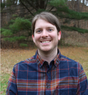
George McCabe is a Software Engineer III for the NSF NCAR Research Applications Laboratory whose skill and commitment have significantly improved the reliability, security, and operational readiness of DTC-supported verification systems. As the lead developer of the METplus Python Wrappers, George plays a central role in delivering a consistent, scalable, and reproducible verification system that is trusted by both research and operational communities.
George’s contributions extend beyond routine software development. He led efforts to resolve complex integration, automation, and cybersecurity challenges keeping DTC-supported verification systems compliant, operationally viable, and on track for delivery within evolving security environments. His work has strengthened METplus as a robust, secure, and mission-ready framework while preserving usability for a broad and expanding user base.
In addition to METplus, George contributes to Air Force Verification and Validation on the Global Synthetic Weather Radar project and the Benchmarking Testing and Evaluation and Verification Framework, advancing scientifically rigorous, reproducible evaluation practices while reducing redundant effort across institutions. He is widely respected for his exceptional ability to translate complex technical and security challenges into practical, sustainable solutions, as well as for his calm, methodical approach to problem solving, particularly during high pressure and high-impact efforts.
George’s initiative, technical leadership, and commitment to excellence consistently go beyond expectations, establishing him as a cornerstone of DTC software development and a profoundly deserving recipient of this recognition.
Copyright © 2026. All rights reserved.
