As a DTC visitor in 2013, Thomas Galarneau has applied a new diagnostic method for quantifying the phenomena responsible for errors in tropical cyclone (TC) storm tracks to an inventory of recent hurricanes.
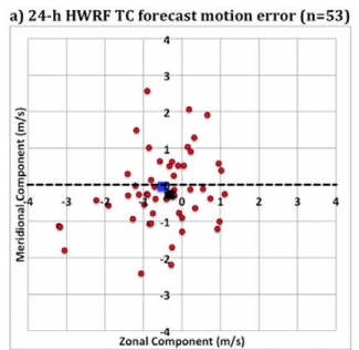
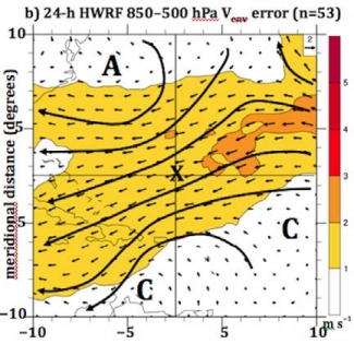
The method is founded on the notion that errors in storm motion at relatively short lead times (12- 48 h) lead to large position errors at later times. The objective of his DTC Visitor Project was to diagnose sources of error in TC motion forecasts from the HWRF model. Of particular interest was the impact of model errors in forecasts of the environmental steering flow at different stages of Atlantic Basin TC evolution. By isolating the vortex structure from the larger-scale flow in a TC-relative framework, he has been able to show (as in the scatterplot in the figure below) that during the northeastward-moving (post-curvature) phase, TC motion errors are generally southwestward. As illustrated in the TC-relative geographical plot of the figure below, this error can be attributed to a northeasterly environment wind error larger than 1.0 m/s, which in turn appears to be associated with an anticyclonic error to the northwest, and a cyclonic error to the southeast, of the forecasted TC. Further details of his project will be available soon at http://www.dtcenter. org/visitors/year_archive/ 2013/ when DTC visitor reports are posted.


