Overview
The Hurricane Weather Research and Forecast system (HWRF) became operational at NCEP in 2007. This advanced hurricane prediction system was developed at the NWS/NCEP's Environmental Modeling Center (EMC), in collaboration with NOAA AOML, NOAA GFDL and the University of Rhode Island, taking advantage of the WRF model infrastructure developed at NCAR. HWRF is a state-of-the-art hurricane model that has the capability to address the intensity, structure, and rainfall forecast problems.
The HWRF model is a primitive-equation non-hydrostatic coupled atmosphere-ocean model with an atmospheric component that employs the Non-hydrostatic Mesoscale Model (NMM) dynamic core of the WRF model (WRF-NMM), with a parent and two nest domains. The parent domain covers roughly 80° x 80° on a rotated latitude/longitude E-staggered grid. The location of the parent domain is determined based on the initial position of the storm and on the NHC/Joint Typhoon Warning Center (JTWC) forecast of the 72-h position, if available. The middle nest domain, of about 24° x 24°, and the inner nest domain, of about 7° x 7°, move along with the storm using a two-way interactive nesting. The stationary parent domain has a grid spacing of 0.135° (about 18 km) while the middle nest grid spacing is 0.045° (about 6 km) and the inner nest grid spacing is 0.015° (about 2 km). The model top and number of vertical levels used in operations is dependent on the basin. In the north Atlantic (AL), north Eastern Pacific (EP), and north Central Pacific (CP) basins, the model top is 10 hPa and 75 levels are used. In the western North Pacific (WP) and north Indian Ocean (NIO) basins, the model top is 10mb and 61 levels are used. In all other basins, the model top is 50hPa and 43 levels are used. The system is flexible so that different model tops and numbers of vertical levels can be used.
HWRF v3.9a includes an updated Scale-Aware Simplified Arakawa-Schubert (SASAS) scheme for cumulus parameterization and the Ferrier-Aligo cloud microphysics package for explicit moist physics. A modified version of the Global Forecast System (GFS) eddy-diffusivity mass flux scheme is used for the planetary boundary layer, along with the modified GFDL surface layer scheme. The Monin-Obukhov scheme is used for surface flux calculations, which employs an improved air-sea momentum flux parameterization in strong wind conditions. The NOAH land surface model is used to represent the land surface for the purpose of calculating the surface fluxes and the amount of upwelling radiation at the lower atmospheric model boundary. Radiation effects are evaluated by the Rapid Radiative Transfer Model for General Circulation Models (RRTMG) scheme, which includes diurnal variations and interactive effects of clouds. The HWRF physics operational suite also includes parameterization of dissipative heating.
The NCEP GFS analysis and forecast, the forecast from the previous cycle of GDAS, and the storm message provided by NHC are used to generate initial conditions for the hurricane model. In cycled mode, the HWRF system uses a forecast/analysis cycle in which the previous HWRF forecast cycle's vortex is used as a first guess to a hybrid data assimilation system. The first guess field is relocated and modified so that the initial storm position, structure and intensity conform to those estimated from the NHC storm message. The initial conditions are calculated by adding the assimilated storm structure back onto the GDAS environmental fields. The GFS forecast fields are used every 6 hours to provide lateral boundary conditions during each forecast.
The atmospheric component of HWRF can be used in atmosphere-ocean coupled mode. In operations, HWRF runs in atmosphere-only mode in the southern hemisphere basins, employs the HYbrid Coordinate Ocean (HYCOM) model in the WP and NIO basins, and employes the MPI Princeton Ocean Model for Tropical Cyclones (MPIPOM-TC) in the AL, EP, and CP basins. The MPIPOM-TC is configured with 1/12° horizontal grid spacing and 40 vertical sigma levels. The MPIPOM-TC is initialized by a diagnostic and prognostic spinup of the ocean circulations using available GDEM climatological ocean data in combination with the GFS real-time sea surface temperature analysis. In the Atlantic, sea surface height data is used to incorporate the structure and positions of the Loop Current, Gulf Stream, and warm- and cold-core eddies. The only ocean model supported in HWRF v3.9a is MPIPOM-TC, which is activated by default for all northern hemisphere basins.
At this time, the Developmental Testbed Center (DTC) supports the following components of HWRF:
- WRF V3.9a (contains the 2017 operational capability)
- WRF Preprocessing System (WPS)
- Vortex Initialization
- Gridpoint Statistical Interpolation (GSI) data assimilation system V3.6
- NCEP Coupler
- MPIPOM-TC and its initialization
- Unified Post-processing (UPP)
- GFDL Vortex Tracker
- Visualization
Software Requirements
The basic requirements for building and running the HWRF system are the following:
- FORTRAN 90/95 compiler
- C compiler
- MPI v1.2+
- Perl
- netCDF V3.6+
- LAPACK and BLAS
- Python
- Parallel-netCDF
- PNG
- JasPer
- zlib
- Plot utilities
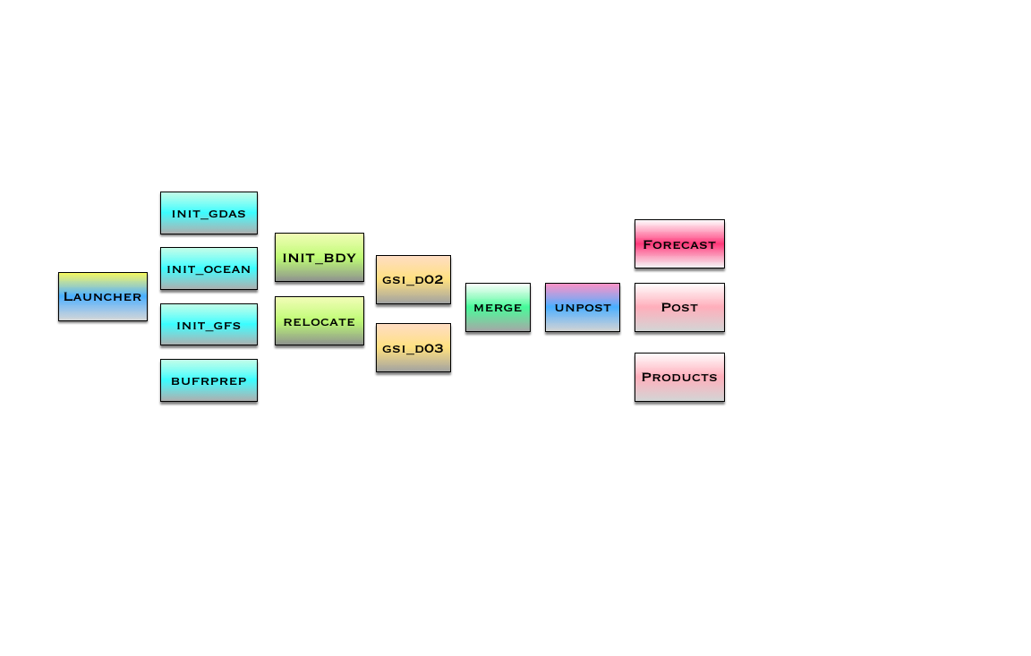
Program Flow
Documentation
Detailed user and scientific documentation for HWRF can be found here: Documents for HWRF v3.9a release