COPYGB (GRIB1)
COPYGB (GRIB1)
COPYGB Functionality
The COPYGB tool was developed by the NOAA Environmental Modeling Center, is distributed by the National Weather Service, Climate Prediction Center, and is also distributed as part of the Unified PostProcessor (UPP). It may be run on GRIB files to horizontally interpolate the data from one grid to another. The MET tools which compare gridded forecasts to gridded observations (Grid-Stat, Wavelet-Stat, Ensemble-Stat and, MODE) require that the input forecast and observation data be on the same grid. Therefore the COPYGB tool is very useful in preparing your gridded data for use in MET.
The following copygb commands assume that copygb is installed on your system and has been added to your path.
COPYGB Usage
If you have copygb installed on your machine, view the usage statement by simply typing the following:
| Usage: copygb | |
| [-g "grid [kgds]"] [-i "ip [ipopts]"] [-k "kpds"] [-v "uparms"] | |
| [-B mapgrib [-b mapindex] [-A "<> mapthreshold"] [-K "mapkpds"]] | |
| [-M "mask"/mergegrib [-m mergeindex]] [-X] [-a] [-N namelist] | |
| then either: grib1 index1 grib2 | |
| or: -x grib1 grib2 |
COPYGB accepts many optional command line options which control its functionality. In this tutorial, we'll focus on the simplest types of horizontal interpolation using the default interpolation options. For a full description of these command line options, please see the copygb.doc COPYGB documentation file.
Run: Predefined
Run: Predefined
In this tutorial, we'll run COPYGB several times to do the following:
- Interpolate to a predefined NCEP grid.
- Interpolate to a user-defined Lat/Lon grid.
- Interpolate to a user-defined Lambert Conformal grid.
- Interpolate to a user-defined Polar Stereographic grid.
Predefined NCEP Grid
First, we'll run the wgrib tool to dump out information about a sample GRIB file:
The -V argument for wgrib dumps out the definition of the grid on which the data resides. This data is on a Lambert Conformal grid with the grid definition parameters listed below:
Lambert Conf: Lat1 12.190000 Lon1 -133.459000 Lov -95.000000
Latin1 25.000000 Latin2 25.000000 LatSP 0.000000 LonSP 0.000000
North Pole (185 x 129) Dx 40.635000 Dy 40.635000 scan 64 mode 8
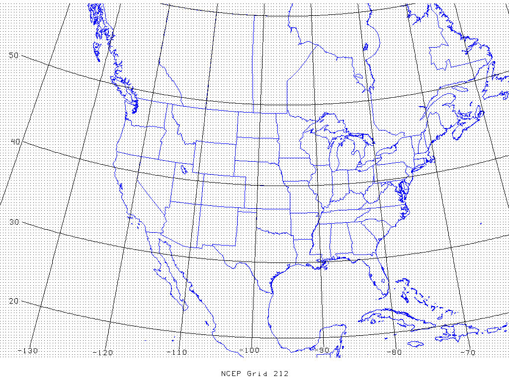
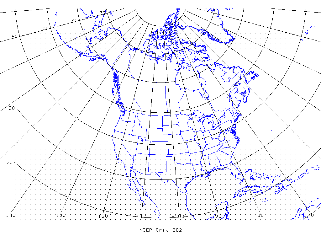
This data resides on NCEP Grid 212 (image), a 40-km Lambert Conformal grid over the contiguous United States. Now run COPYGB on this file to interpolate this data to NCEP Grid 202 (image), a 190-km Polar Stereographic grid:
copygb.exe \
-xg 202 \
$MET_TUTORIAL_DATA/input/sample_obs/ST2ml/ST2ml2005080712.Grb_G212 \
$MET_TUTORIAL_DATA/output/copygb/ST2ml2005080712.Grb_G202
In the command above the -x option indicates that we want the data to be extracted and the -g 202 option indicates that the data should be interpolated to NCEP Grid 202. Next, run wgrib on the output and note that the grid definition has changed:
The resulting grid definition parameters are listed below:
polar stereo: Lat1 7.838000 Long1 -141.028000 Orient -105.000000
north pole (65 x 43) Dx 190500 Dy 190500 scan 64 mode 9
For a list of the predefined NCEP grids available, please see:
http://www.nco.ncep.noaa.gov/pmb/docs/on388/tableb.html
Run: Lat/Lon
Run: Lat/Lon
For most users of WRF and MET, using the predefined NCEP grids will not suffice. Instead, you will often want to interpolate to the domain on which your model data resides. This is easy to do with COPYGB but will require you to define the grid to be used on the command line. The grid definition arguments to COPYGB differ based on the type of projection used. Listed below are the arguments for user-defined Lat/Lon grids:
copygb -g"255 0 NX NY LAT0 LON0 128 LAT1 LON1 DX DY 64" -x in.grb out.grb
| where | ||
| 255 0 | User-defined Lat/Lon grid | |
| NX | Number of points on latitude circle | |
| NY | Number of points on longitude meridian | |
| LAT0 | Latitude of origin * 1000 (lat = -90 ... 90) | |
| LON0 | Longitude of origin * 1000 (lon = -180 ... 180) | |
| 128 | ||
| LAT1 | Latitude of extreme (last) point * 1000 | |
| LON1 | Longitude of extreme (last) point * 1000 | |
| DX | Longitudinal increment in millidegrees | |
| DY | Latitudinal increment in millidegrees | |
| 64 |
Please note that all of the grid definition parameters must be integers. All latitude, longitude, and increments values are given in thousandths of a degree.
User-Defined Lat/Lon Grid
Let's define a Lat/Lon grid over the central United States as follows:
- Latitude ranging from 35N to 45N
- Longitude ranging from 105W to 90W
- 0.5 degree grid spacing
Translate this definition to the COPYGB grid specification as follows:
- NX = 30
- NY = 20
- LAT0 = 35000
- LON0 = -105000
- LAT1 = 45000
- LON1 = -90000
- DX = 500
- DY = 500
Plug these numbers into the grid specification and run COPYGB as follows:
-xg"255 0 30 20 35000 -105000 128 45000 -90000 500 500 64" \
$MET_TUTORIAL_DATA/input/sample_obs/ST2ml/ST2ml2005080712.Grb_G212 \
$MET_TUTORIAL_DATA/output/copygb/ST2ml2005080712.Grb_latlon
Lastly, run wgrib on the COPYGB output and make sure the grid definition matches what you expected:
Run: Lambert conformal grid
Run: Lambert conformal grid
The COPYGB grid definition parameters for Lambert Conformal grids are listed below:
copygb -g"255 3 NX NY STARTLAT STARTLON 8 CENLON DX DY POLE 64 TRUELAT1 TRUELAT2" -x in.grb out.grb
| where | ||
| 255 3 | User-defined Lambert Conformal grid | |
| NX | Number of points on latitude circle | |
| NY | Number of points on longitude meridian | |
| STARTLAT | Southwest corner latitude * 1000 (lat = -90 ... 90) | |
| STARTLON | Southwest corner longitude * 1000 (lon = -180 ... 180) | |
| 8 | ||
| CENLON | Center longitude * 1000 | |
| DX | Longitudinal increment in meters | |
| DY | Latitudinal increment in meters | |
| POLE | Northern (0) or southern (128) hemisphere | |
| 64 | ||
| TRUELAT1 | First true latitude * 1000 | |
| TRUELAT2 | Second true latitude * 1000 |
Please note that all of the grid definition parameters must be integers. All latitude and longitude values are given in thousandths of a degree. The grid increments are given in meters.
User-Defined Lambert Conformal Grid
Rather than defining a Lambert Conformal manually, we'll use the output of wgrib to define the grid we'd like to use. Let's look again at the wgrib output for NCEP grid 212:
Here is the grid definition:
Lambert Conf: Lat1 12.190000 Lon1 -133.459000 Lov -95.000000
Latin1 25.000000 Latin2 25.000000 LatSP 0.000000 LonSP 0.000000
North Pole (185 x 129) Dx 40.635000 Dy 40.635000 scan 64 mode 8
Translate this definition to the COPYGB grid specification as follows:
- NX = 185
- NY = 129
- STARTLAT = 12190
- STARTLON = -133459
- CENLON = -95000
- DX = 40635
- DY = 40635
- TRUELAT1 = 25000
- TRUELAT2 = 25000
Plug these numbers into the grid specification and run COPYGB follows:
-xg"255 3 185 129 12190 -133459 8 -95000 40635 40635 0 64 25000 25000" \
$MET_TUTORIAL_DATA/input/sample_fcst/2009123112/arw-fer-gep1/d01_2009123112_02400.grib \
$MET_TUTORIAL_DATA/output/copygb/d01_2009123112_02400.grib_lambert
Lastly, run wgrib on the COPYGB output and make sure the grid matches the one listed above:
Run: Polar Stereographic
Run: Polar Stereographic
The COPYGB grid definition parameters for Polar Stereographic grids are listed below:
copygb -g"255 5 NX NY STARTLAT STARTLON 8 CENLON DX DY POLE 64" -x in.grb out.grb
| where | ||
| 255 5 | User-defined Polar Stereographic grid | |
| NX | Number of points on latitude circle | |
| NY | Number of points on longitude meridian | |
| STARTLAT | Southwest corner latitude * 1000 (lat = -90 ... 90) | |
| STARTLON | Southwest corner longitude * 1000 (lon = -180 ... 180) | |
| 8 | ||
| CENLON | Center longitude * 1000 | |
| DX | Longitudinal increment in meters | |
| DY | Latitudinal increment in meters | |
| POLE | Northern (0) or southern (128) hemisphere | |
| 64 |
Please note that all of the grid definition parameters must be integers. All latitude and longitude values are given in thousandths of a degree. The grid increments are given in meters.
User-Defined Polar Stereographic Grid
Again, let's look at the wgrib output for a Polar Stereographic grid and use it to define the grid definition arguments for COPYGB. Run wgrib on a Polar Stereographic dataset:
Here is the grid definition:
polar stereo: Lat1 7.838000 Long1 -141.028000 Orient -105.000000
north pole (65 x 43) Dx 190500 Dy 190500 scan 64 mode 9
Translate this definition to the COPYGB grid specification as follows:
- NX = 65
- NY = 43
- STARTLAT = 7838
- STARTLON = -141028
- CENLON = -105000
- DX = 190500
- DY = 190500
- POLE = 0
Plug these numbers into the grid specification and run COPYGB follows:
-xg"255 5 65 43 7838 -141028 8 -105000 190500 190500 0 64" \
$MET_TUTORIAL_DATA/input/sample_obs/ST2ml/ST2ml2005080712.Grb_G212 \
$MET_TUTORIAL_DATA/output/copygb/ST2ml2005080712.Grb_stereo
Lastly, run wgrib on the COPYGB output and make sure the grid matches the one listed above: