
As part of the Unified Forecast System (UFS) effort, a Limited Area Model (LAM) is under development, based on the non-hydrostatic Finite Volume Cubed-Sphere Dynamical Core (FV3), to achieve high-resolution forecasts. This project leverages the available environment provided by current UFS developments to investigate the Rapid Refresh Forecast System (RRFS) skill in representing the structure of convection generated by squall lines over the Great Plains of the United States.
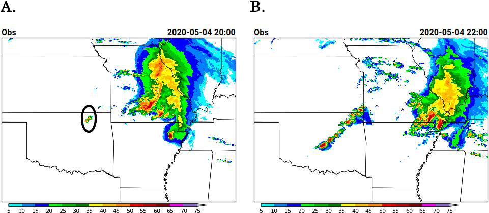
Squall lines occur with a high frequency in this region, causing severe weather events and much of the precipitation that falls there throughout the year. A pre-frontal squall line over Oklahoma on 4 May 2020 is the case under study. Convective initiation was observed over northeastern Oklahoma at 20Z and around 22Z a line of storms evolved that extended across the state (Fig. 1), resulting in several high-wind and large-hail events.
The Gridpoint Statistical Interpolation (GSI) data assimilation (DA) system was used for the analysis and the Model Evaluation Tools (MET) for verification. The GSI 3-dimensional variational (3DVAR) DA capability was tested, along with two physics suites: GFS-based physics and the suite developed at NOAA’s Global Systems Laboratory (GSD SAR). Hourly cycles with 18-hour forecasts starting at 00Z on May 4th through 06Z, May 5th were performed.
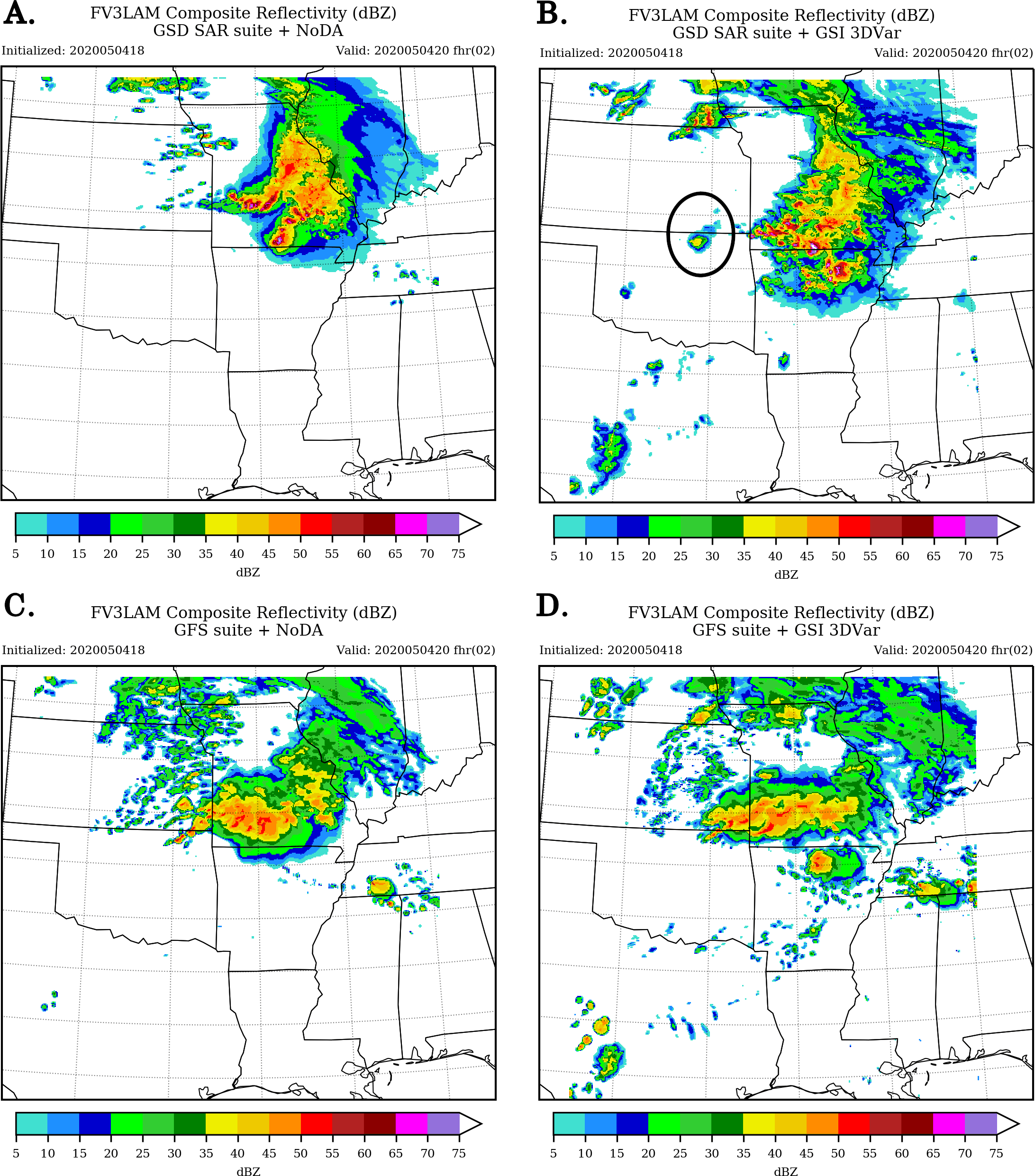
Results from the 2-h forecast initialized at 18Z suggest that the GSD SAR suite with DA experiment was able to represent the initial convection over northeast Oklahoma (see black circles in Fig. 1-A and 2-B), but forecast cycles prior to that initialized at 17Z failed to capture the initial convection over Oklahoma at 20Z (not shown). Experiments using the GFS suite performed poorly for the convective initiation over Oklahoma up to the 20Z valid hour (Fig. 2-D).
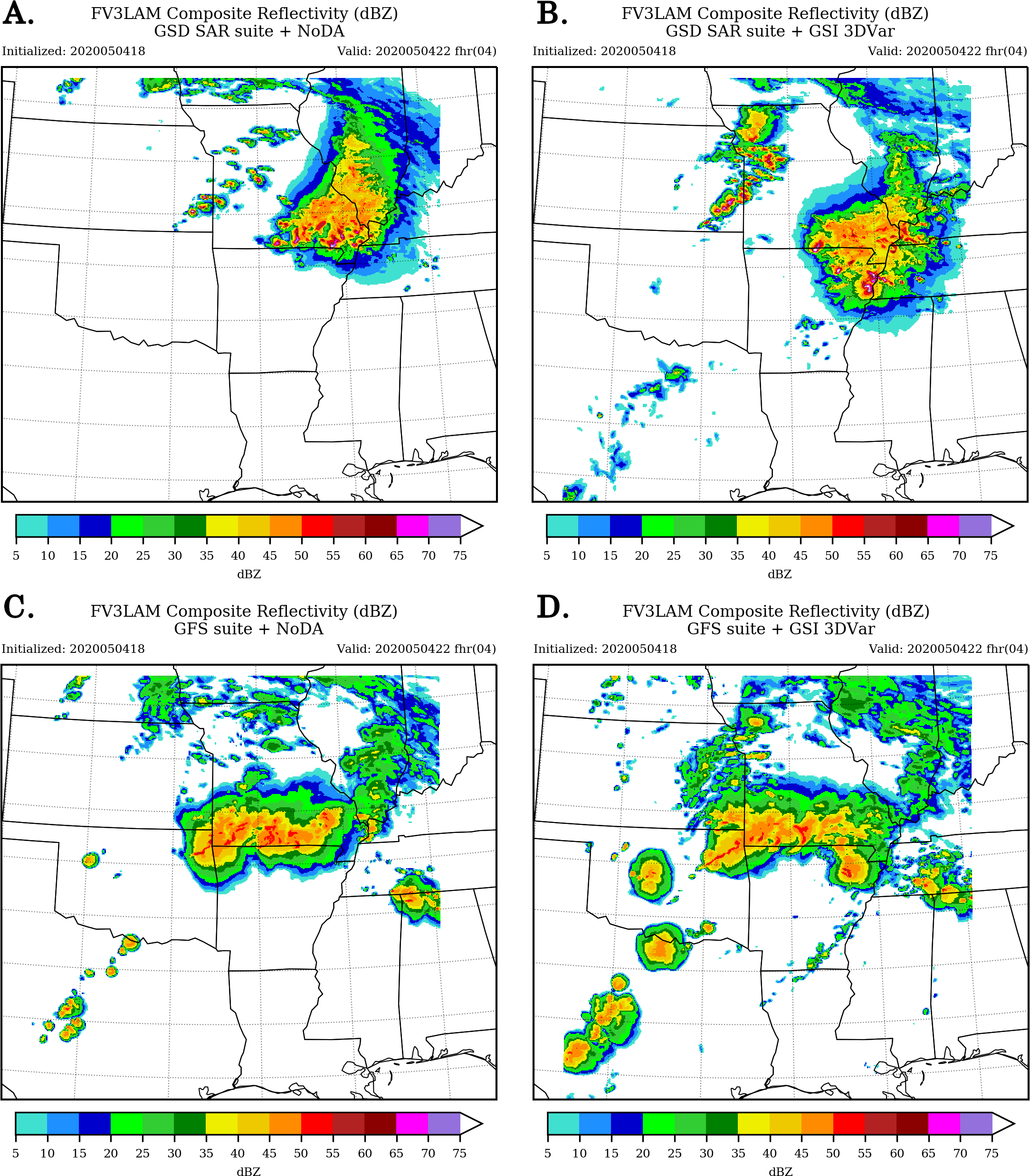
Although more convection developed over other states, a slightly better representation of the squall-line structure is shown after 21Z in the experiments using the GFS suite when compared to the GSD SAR experiments, especially when using DA (Fig. 3-D). The experiments using the GSD SAR suite do not reproduce the evolution of the squall line over Oklahoma and instead, a line of storms developed northward of the observed one (Fig. 3-A and 3-B). After 22Z, the GFS experiments continue to do a better job capturing the squall line structure over Oklahoma while the GSD SAR experiments miss this system until the last cycle. Nevertheless, the convection over Arkansas, Missouri and Illinois is better captured in the experiment using the GSD SAR suite with DA.
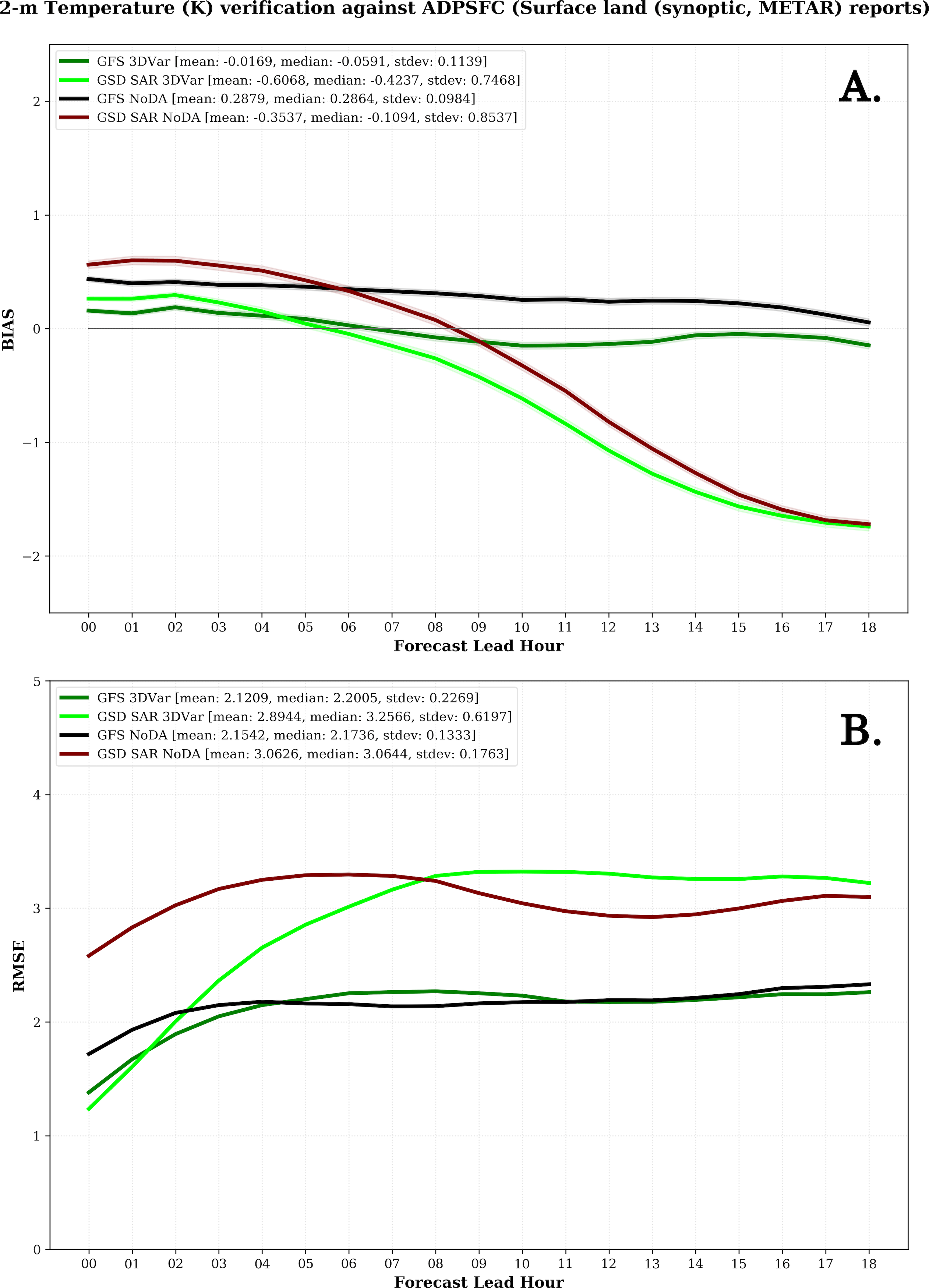
The forecasted 2-m temperature provides further insight into strengths and weaknesses of the configurations in each experiment. Larger bias is observed with longer forecast length when using the GSD SAR suite (Fig. 4-A). After the 5-h forecast, the 2-m temperature forecasts are cooler than the observations by up to 1.74 K. A high positive DA impact is observed for RMSE results up to the 8-hour forecast, after which the impact becomes negative (Fig. 4-B). The forecasts generated using the GFS physics suite have a RMSE and bias that are generally smaller than those associated with the GSD physics suite. The inclusion of DA reduces the bias for all lead times and reduces the RMSE but only during the first 4 hours of the forecast.
To understand the elements that are limiting the initiation and overproduction of convection in GFS experiments and the convection evolution in the GSD SAR experiments, future work will test the GSI hybrid (3DEnVar) analysis and adjust parameters related to cloud analysis and surface-data analysis enhancements.
This visitor project forms part of my doctoral research at CPTEC/INPE (Brazil) and has been underway since March 2020. I am grateful to the DTC for this opportunity, especially to Louisa Nance, Ming Hu, Guoqing Ge, Will Mayfield, Eric Gilleland, Jacob Carley, Daryl Kleist, and my academic advisor Luiz Fernando Sapucci, for their guidance and support during this time.