I’d like to highlight some recent work in model diagnostics by my one-time colleague in NOAA Physical Science Division, Thomas Galarneau. Tom was funded under a DTC visitor’s program grant, with additional funding through the Hurricane Forecast Improvement Project. As a DTC visitor in 2013, Tom applied a new diagnostic method for quantifying the phenomena responsible for errors in tropical cyclone (TC) storm tracks to an inventory of recent hurricanes. (See a related article about Tom’s work in the DTC Newsletter Winter-Spring 2014, page 4.) Tom has since moved on to NCAR, and then more recently to the University of Arizona.
Readers are likely aware that the prediction of tropical cyclone track, intensity, and genesis in the medium-range (120–180-h forecast leads) continues to be a formidable challenge for operational numerical weather prediction models.
While 36–84-h TC track predictions from the operational NCEP Global Forecast System (GFS) have significantly improved over the last ten years, predictions for forecast leads beyond 120-h have shown no such improvement. In order to examine and diagnose medium-range forecasts for the NCEP GFS, Tom and his NCAR colleagues Chris Davis and Bill Kuo developed the Real-Time Diagnosis of GFS Forecasts website [http://www.atmo.arizona.edu/~tgalarneau/realtime/gfs_diagnostics.html] that provides analyses and diagnoses of GFS forecasts in real time. To complement other websites that show the statistics of GFS forecast performance, this website provides synoptic charts and diagnostic calculations to link model physical processes to the evolution of the synoptic-scale flow in the GFS forecast. Analyses and diagnostics are generated four times daily, and they provide information on how the GFS has behaved over the previous 60-day period. A wide variety of charts can be generated at the web site above.
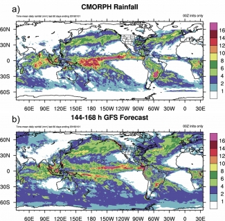
Consider one relatively simple example of a systematic error in the GFS identified with this web site. Since its inception, continuous monitoring of the GFS forecasts has revealed that the GFS systematically loses atmospheric water vapor over the tropical west Pacific in quiet regimes during the summer months. It appears that the GFS atmosphere overturns early in the forecast, producing a positive rainfall bias in the day-1 forecast over the tropics. The GFS atmosphere does not recover from the stabilization following the early burst of rainfall due to a low surface flux bias. As a consequence, the GFS atmosphere continues to dry and stabilize through the medium-range, resulting in the negative rainfall bias over the tropics by day 7. The drier conditions make it difficult for the GFS to accurately predict TC genesis in the medium range. Examination of rainfall forecasts over the last 60 days of 2015 shows that the dry bias in the tropics is also a problem during the cool season. The attached figure shows a systematic inability of medium-range GFS forecast to maintain tropical rains associated with a westerly wind burst along the equator in the tropical west-central Pacific. With tropical cyclone formation and propagation affected by this bias, one can expect that tropical-midlatitude interactions in the eastern Pacific are affected, which of course can affect the accuracy of downstream forecasts over the US.
Identification of major systematic biases in our forecast model is the first step toward better predictions. I personally would like to see DTC do even more in this arena, producing diagnostics that further aid the model developer in teasing out the underlying sources of model biases. Can the systematic errors Tom identified be attributed to convective parameterizations? To cloud-radiative feedbacks? The faster we can diagnose the ultimate potential sources of forecast bias, the more rapidly we can reallocate the development resources to address them, thus speeding the rate of forecast system improvement. Tom and his colleagues pioneering work is a very admirable first step in this process, for which NOAA and the weather enterprise is grateful.
Tom Hamill is a research scientist who is interested in all aspects of ensemble weather and climate prediction, from data assimilation to stochastic parameterization to post-processing and verification. Tom also is currently a member of the DTC management board and is a co-chair of the World Meteorological Data Assimilation and Observing Systems working group.


